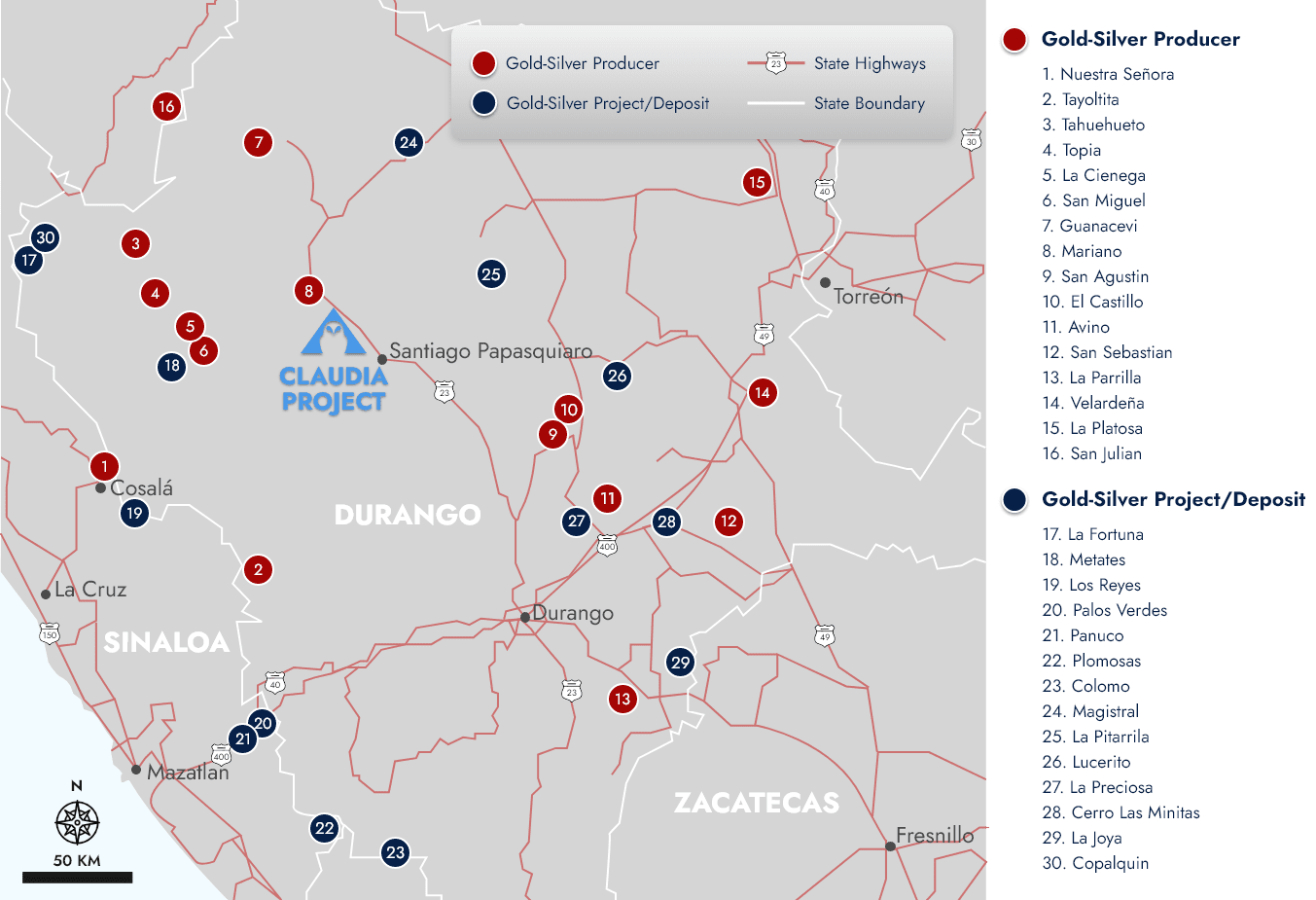
Ownership & Description
- 100% owned by Pacifica Silver. A 3% Net Smelter Return (NSR) is held by Grupo Minero Bacis, S.A. de D.V., of which 1.5% can be repurchased for US$600,000.
- Property consists of 36 contiguous titled mining concessions and one application totalling 11,876 hectares encompassing most of the historic Papantón mining district in Santiago Papasquiaro, Durango, Mexico.
Location, Topography & Climate
- The Project is centered on the geographic coordinates 25.09°N of latitude and 105.564°W of longitude, ~145 km northwest of the city of Durango (3 hours by car) and 15 km northwest of the town of Santiago Papasquiaro (<1 hour drive by car) in the state of Durango, Mexico.
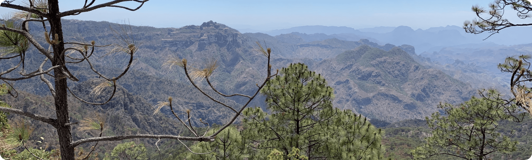
- Elevations range from 1,800 to 2,900 m. Topography is moderately rugged with high, flat ridges surrounded by valleys and canyons. Most of the property is forested with mixtures of pine and oak trees. Other vegetation consists of grasses, mesquite, huizache and crasicuale bushes.
- Climate is semi-arid with moderate temperatures during the summer months (maximum temperatures of ~30°C to 35°C), and cooler temperatures in the winter months that may reach a few degrees below 0°C.
- Average annual precipitation is approximately 200 mm but can reach upwards of 800 mm in heavy rainfall years. The rainy season extends from July-November with occasional rain during December and January. Snowfall is infrequent but can occur from December-February and is generally less than a few centimetres.
- Mining and exploration can be conducted year-round.
Access & Infrastructure
- Access is from the city of Durango via paved highways for approximately 150 km north and west to the city of Santiago Papasquiaro, then a further 10 km north by highway to a junction with another paved, two-lane highway. Proceeding west on MEX 36, the Claudia property is transected by highway MEX 36 and accessed via a network of improved but unpaved roads that intersect MEX 36 approximately 13km west of the junction with MEX 23.
- Fuel, supplies, communications, accommodations, banking, rural health clinics, and a skilled labour force are available 15 km away in the city of Santiago Papasquiaro (Population ~49,000).
- Diesel construction and mining equipment, along with engineering, banking, and mining services and an international airport are available in the city of Durango (Population ~616,000).
- City of Durango has a large labour pool with mining, construction, administrative and engineering skills. Many drilling and contract mining companies are based in the city along with large and modern commercial assay and metallurgical laboratories, including SGS.
- Electrical power is potentially available from the regional power grid. A major regional power line crosses the property along highway MEX 36.
- Water for exploration drilling is generally available from surface run-off, storage ponds and seasonal streams within the property during July through October.
Geology & Mineralization
- The property is situated in the eastern part of the Sierra Madre Occidental (SMO) geologic province, near the regional San Luis-Tepehuanes fault system and the transition between the Basin-and-Range and Mesa Central provinces of Mexico.
- The property is centered on a northwest-elongate erosional window into andesite, andesitic volcanic breccia and interbedded rhyolite tuffs, that are overlain and surrounded by rhyolite breccias and variably welded rhyolite ash-flow tuffs.
- Gold-silver mineralization is found in an array of sub-parallel to anastomosing epithermal quartz veins within north- to northwest-striking faults, and in sheeted-vein and vein-stockwork zones between vein splays and near vein intersections. These include the Aguilareña, Guadalupana, Tres Reyes, Mina Vieja, La Concepción, Santiaguera, Mina de Oro, El Grullo, Noche Buena, Don Jose, El Cristo, and Lizeth veins.
- Mineralized veins range from 1-10 m in true width, with wider zones of vein breccia and stockwork developed near vein intersections.
- Locally, veins and associated quartz cemented vein breccia reach estimated true widths of up to 40 m.
- Widths of 0.5-15 m have been reported at the Aguilareña vein and widths of 1.0-15 m have been reported for the Guadalupana vein.
- At the Lizeth vein swarm, there are closely spaced and sheeted quartz veins that together form a 250-m-wide zone of potential bulk mineralization.
- The gangue mineralogy of the veins consists mainly of banded quartz, adularia, and occasional small amounts of calcite.
- Where unoxidized and mineralized, veins contain small quantities of pyrite with lesser amounts arsenopyrite, ± sphalerite, ± galena, ± argentite, ± electrum, and ± gold.
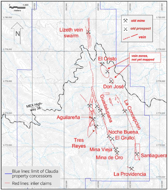
Historical Prospects and Mines in the Claudia Property (Durango Gold, 2022)
Hachured lines are unpaved access roads; 20 meter contours 1:50,000 G13-C48; 2km UTM grid lines, WGS84
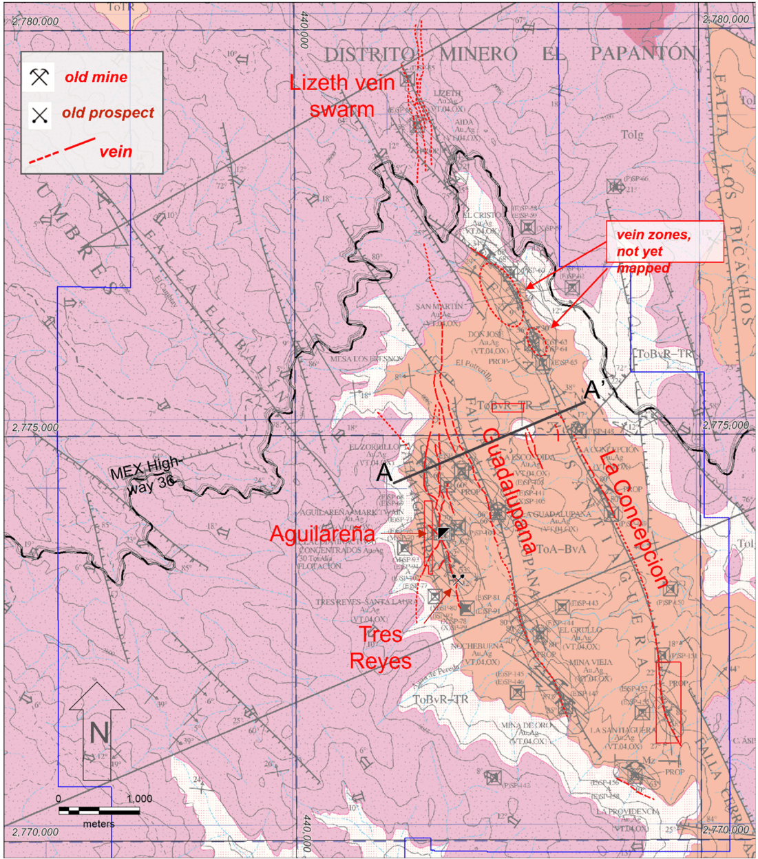
Geologic Map and Principal Gold-Silver Veins, Central Part of Claudia Property
(modified from Luevano Pinedo et al., 2003)
Note: blue lines are limit of Claudia property concessions. Red lines show veins modified from undated Silverstone map and Durango Gold 2021 mapping, short dashes where inferred. Solid red outlines are inactive 3rd - party claims. Black grid lines at 5km spacing, UTMWGS84.
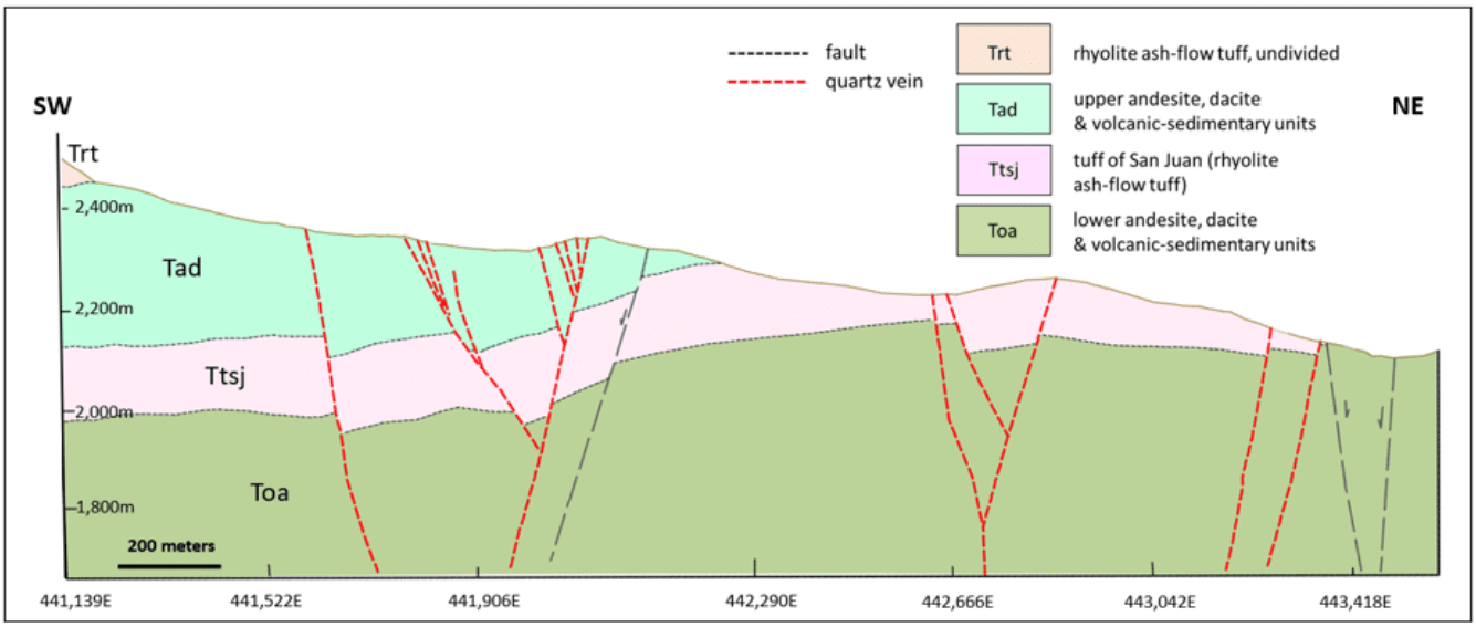
Generalized Cross-Section A - A', Aguilareña and Guadalupana Area
(from Durango Gold 2021, looking northwest)
Production & Exploration History
Pre-1960s
No records exist of when mineralization was discovered at the Claudia Project. Several historical mine waste-rock piles and approximately 2,000 m³ of stockpiled mineralized material, linked to artisanal and small-scale mining before the mid-1990s, form the historic El Papantón mining district. No historical production records are available for the mines on the property.
1960s
Compania Minera San Gregorio operated a 50 tonne-per-day mill, exploiting mineralization from the Aguilareña, Mark Twain and Santa Teresa veins.
1980
Consejo de Recursos Minerales (CRM) rehabilitated portions of the 3 Reyes workings and carried out underground mapping and sampling under contract with a former owner of the concessions.
Late 1980s
Grupo Gaytan, S.A. de C.V. of Torreon, Coahuila, gained control of the mine and optioned it to BP Minerals and Peñoles but no significant work was completed by these companies.
1991 - 1994
Compania Minera Bacis, S.A. de C.V. (Bacis) optioned the property and drilled 33 diamond core holes totalling 4,346 m but some data has been lost. Thereafter, Bacis acquired the property and completed 3,057 m of drifts, raises, and a 94 m shaft at Aguilareña. They also completed a historical mineral reserves and mineral resources estimate for the Aguilareña area using sampling information from underground developments along with underground and surface diamond drilling.
2004 - 2005
Capstone Mining Corp. (Capstone) optioned the property Bacis in January 2004 and ownership of the property was transferred from Bacis to Silverstone S.A. de C.V., a Mexican subsidiary of Capstone, under the terms of a restated option agreement dated November 30, 2005.
2004 - 2007
Capstone and Silverstone carried out significant surface mapping and geochemical sampling and drilling. Silverstone drilled 10 diamond holes in 2007 in the Aguilareña area for a total of 1,945m, but only partial records of the sample and assay data sets have been recovered.
2009
Silverstone was purchased by Silver Wheaton Corp. Late in 2009, Silver Wheaton sold Silverstone to a group of private Mexican investors.
January
2021
Silverstone assigned the ownership of the Claudia property to Cielo Azul in and transferred title of the Claudia mining concessions to Cielo Azul.
February
2021
Durango Gold Corp. (Durango Gold) entered into a partnership and earn-in agreement with Cielo Azul and later purchased Cielo Azul from Silverstone for 100% ownership of the Claudia property.
March
2021 - 2022
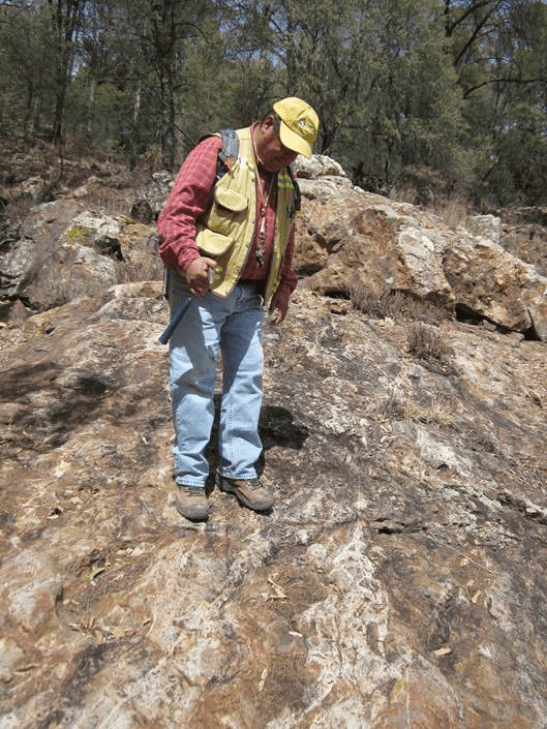
The majority of the exploration work material to the Claudia Project were conducted by Durango Gold between 2021 and 2022. In March 2021, Durango Gold initiated exploration work consisting of prospecting, mapping (focused on the Aguilarena -Tres Reyes and Guadalupana area), rock sampling (840 primary channel and rock-chip samples) and a drill program of 36 diamond drill holes totalling 7,915.9 m.
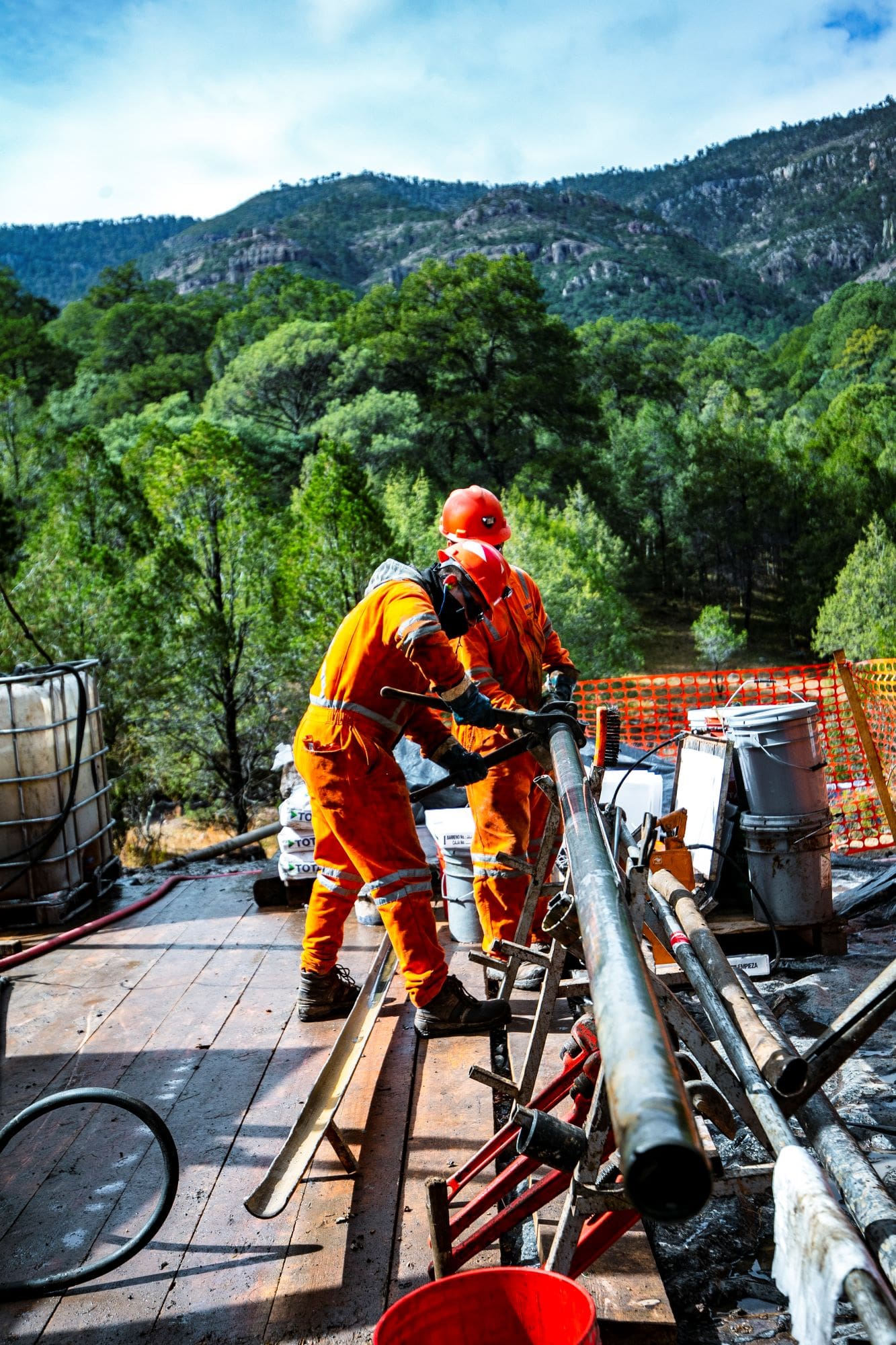
Durango Gold Drilling September 2021
Environmental & Permitting
- There are no known environmental liabilities, violations or fines related to environmental regulations applicable to the Claudia property or previous operators’ exploration activities.
- Exploration activities such as rock and soil sampling, geological mapping and geophysical surveys can be conducted without environmental permits.
- Drilling and mechanized trenching involving minimal construction of access roads and little or no cutting of trees require the filing of an Informe Preventivo (IP) with the Secretaría de Medio Ambiente y Recursos Naturales (SEMARNAT). A complete and properly filed IP requires no more than 30 days for approval.
- If significant construction of access roads and drill pads are required, approval must be obtained from SEMARNAT of a Manifestacion de Impacto Ambiental (MIA), which can take up to six months for approval.
- Surface access agreements with the owners of the surface estate are required for the application of both the IP and MIA. At Claudia, the surface estate is held by four local communities (comunidades), one area of communal land used for agriculture (ejido) and by a single private individual. Mexican mining law provides a legal framework for establishing surface rights to enable exploration and exploitation of mineral resources from areas where the surface estate is owned by ejidos and communities.
- An Informe Preventivo permitting 146 drill sites with minimal surface disturbance, suitable for track mounted or man-portable type diamond-core drills, was approved by SEMARNAT on August 30, 2021 and will expire after five years.
2021 Exploration & Drill Results
- From 2021 to 2022, Durango Gold completed a drill program of 36 diamond drill holes totalling 7,916 metres, primarily focused on the Aguilareña, Guadalupana and Tres Reyes veins.
- A highlight was Hole 21CLAU011D which intersected 4.05 m at an average of 10.54 g/t Au and 317 g/t Ag, including 1.10 meters with 20.80 g/t Au and 557 g/t Ag and is notable for being located 600 m north of the Aguilareña shaft. True widths are estimated to be about 80% to 90% of the reported intervals.
- Full results from the 2021 Drill Program are shown in the table below. AuEq80 represents Gold Equivalent grade calculated at a 80:1 Au/Ag metal price ratio. A map of drill hole locations follows the table.
Summary of Mineralized Intervals, 2021 Drilling by Durango Gold
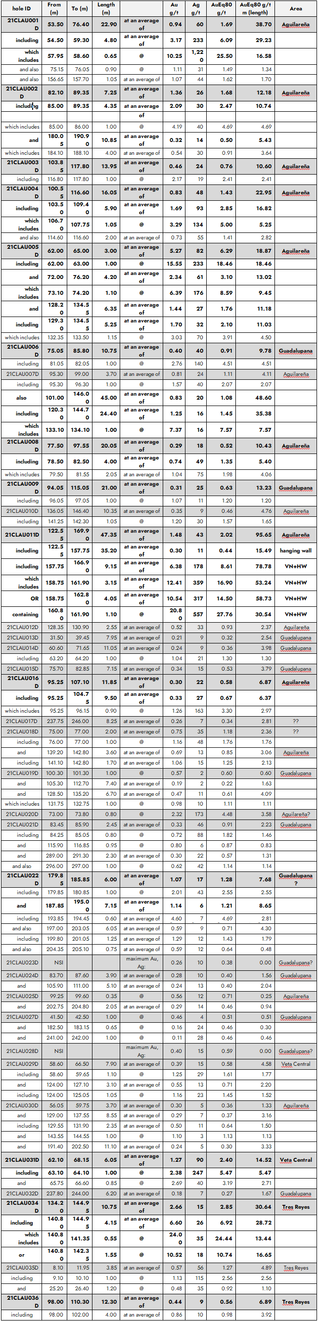
Note: true widths are estimated to average 80% to 90% of the reported interval lengths; highlighted intercepts have equal or greater than 5 AuEq80 g/t m (sample length).
Map of Central Claudia Project with Durango Gold and Historical Drill Holes
(from Durango Gold, 2022)
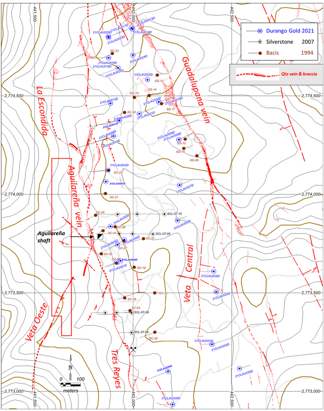
3rd-party inactive inlier claim in red. Brown dots are 1994 Bacis holes; blue dots are 2007 Silverstone holes. Vein surface traces modified from undated Silverstone map. 20-meter contours, UTM WGS84. Grey hachured lines are unpaved roads and tracks